Most people think of history as something preserved in museums — behind glass, labeled, kept at a safe distance. Pittsburgh is different. Walk across one of its hundreds of bridges, stand in a converted warehouse in the Strip District, or drive the valley road past the hulking remnants of a steel mill, and history is pressing against you from every direction. The city is a layered landscape, meaning each era of human activity left physical marks that are still readable today, stacked on top of one another like geological strata. If you want to genuinely understand how America became an industrial superpower — and what happens when that era ends — Pittsburgh is one of the most instructive places on earth to look.
Why Geography Was Destiny
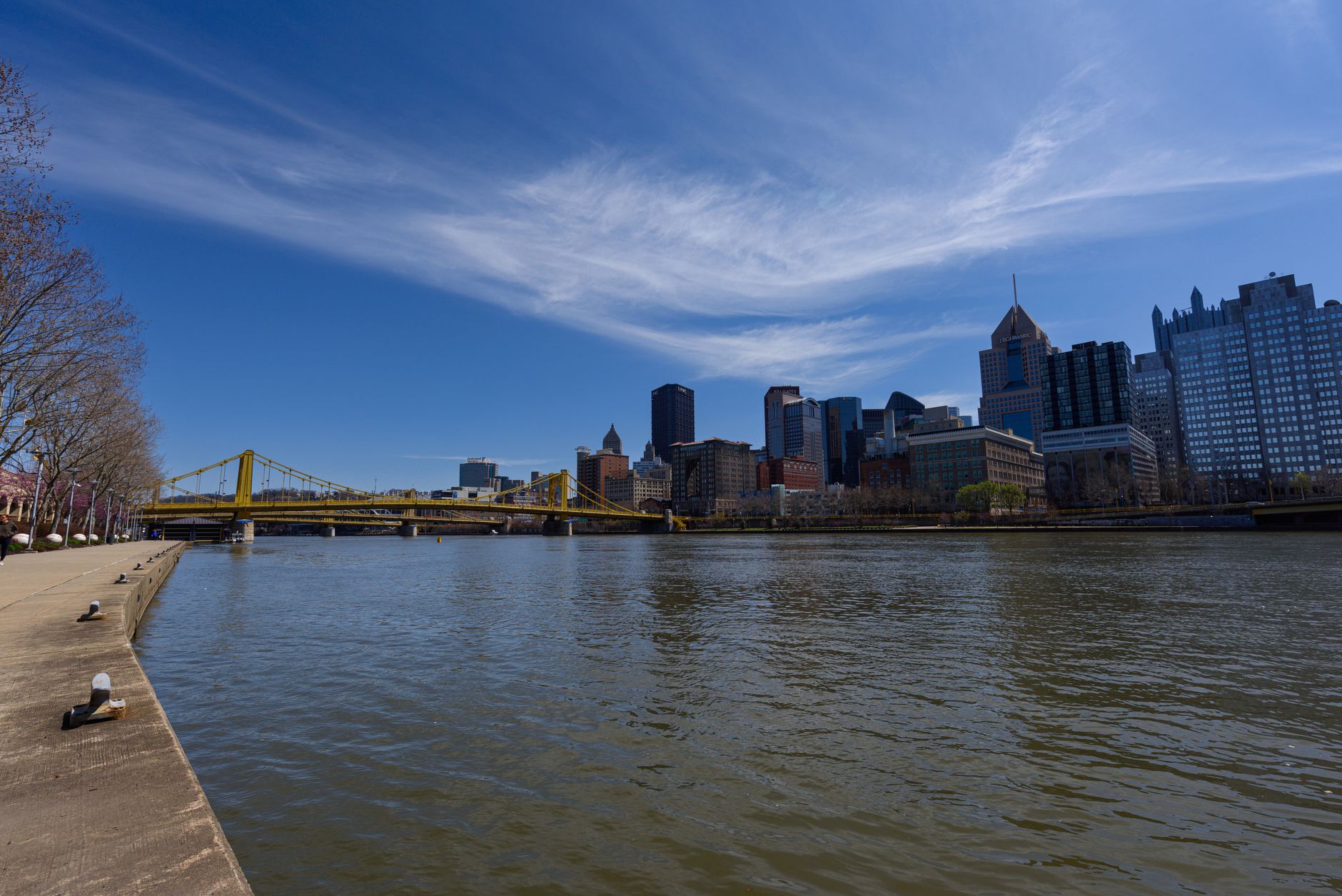
To understand Pittsburgh, start with a map. Better yet, find a high point — Mount Washington on the South Side works beautifully — and look down. You'll see two rivers converging directly in front of you to form a third. That meeting point is not incidental. It is the reason the city exists at all.
Pittsburgh is situated at the confluence of three rivers — the Allegheny, Monongahela, and Ohio — a geographic feature that made it strategically vital for both trade and industrial production from the 18th century onward. Before roads, before railways, rivers were highways. Goods traveled downstream on flatboats; raw materials arrived by water. A city sitting at the junction of three navigable rivers had something almost no other location could offer: natural connectivity in every direction.
This wasn't lost on anyone. The French built a fort here in the 1750s. The British wanted it badly enough to fight for it. When the young United States began industrializing in earnest, Pittsburgh was already a logical nerve center — materials could arrive, products could ship, and a workforce could gather.
But rivers and hills do something else, too: they divide. Pittsburgh's terrain is famously dramatic — steep ridges and deep valleys carved by those same waterways. This forced the city to build its neighborhoods in relative isolation from one another, perched on hilltops or tucked into valley floors, each with its own commercial strip, its own character, its own history. Understanding Pittsburgh's neighborhoods means understanding that geography created them.
💼 Career Opportunities
The Bridge City: Connecting a Divided Landscape
If three rivers divide Pittsburgh, bridges are what hold it together — and there is no city on earth with more of them. Pittsburgh has more bridges than any other city in the world — commonly cited at over 440 — a direct consequence of its three-river geography and the need to connect its many distinct hillside neighborhoods.
That number isn't a curiosity. It's a record of every time the city decided that connection mattered enough to build it. Each bridge generation also tells an engineering story: earlier iron and steel truss bridges (a design that Pittsburgh's own steel industry made economical and widespread) sit alongside 20th-century concrete spans. Walking or driving across them, you're moving through an open-air catalog of American bridge-building history.
The famous "Three Sisters" on the Allegheny River — three nearly identical self-anchored suspension bridges built in the 1920s — are particularly striking, not just as engineering but as civic statement: someone decided that three crossings in close proximity should look coordinated, even beautiful. That impulse, to make industrial infrastructure aesthetically intentional, runs through Pittsburgh's built environment in ways that reward careful attention.
The Steel Mill That Changed America
No single structure better illustrates Pittsburgh's industrial significance than the Edgar Thomson Steel Works in Braddock, a small borough just up the Monongahela from the city. It's still there, still operating, and still visually overwhelming if you drive past it today.
Andrew Carnegie's decision to build his first large-scale steel mill — the Edgar Thomson Steel Works — in Braddock, Pennsylvania, just outside Pittsburgh, in 1875 is widely credited with transforming the regional economy and establishing the template for American industrial-scale manufacturing.
What made this significant wasn't simply that it made steel. It was how it made steel — applying the new Bessemer process (a method that converts molten iron into steel by blasting air through it, dramatically cutting the time and cost of production) at a scale that had never been attempted. Carnegie was obsessed with efficiency and cost reduction. The mill was designed from the ground up to move materials through in a continuous, logical flow, minimizing wasted labor and time. This approach — treating a factory as a system, not just a collection of machines — became the template that other American manufacturers would follow.
The surrounding town of Braddock grew up entirely in the mill's shadow: worker housing, churches, commercial streets. Today Braddock is one of the most striking examples in America of what deindustrialization does to a community built around a single industry. The Carnegie Library he built there — one of the first he ever funded — still stands, a reminder that the same man who built the mill also believed in leaving something more than payroll behind. Both the ruin and the library are worth seeing.
The Strip District: Reading Adaptive Reuse
If Braddock shows you what a mill town looks like at the source of production, the Strip District shows you what a supply and distribution hub looks like after it's been repurposed — and how cities can transform without erasing their history.
The Strip District, once a concentrated hub of warehouses and produce markets serving Pittsburgh's industrial workforce, dates its commercial character to the mid-19th century and has undergone significant adaptive reuse since the steel industry's decline in the 1970s and 1980s.
"Adaptive reuse" is an architectural term worth understanding: it means taking a building designed for one purpose and converting it for a different one, while retaining the original structure. The alternative — demolition and replacement — loses the physical record of what was there. The Strip District chose a different path. The long, low warehouse buildings that once stored wholesale produce, meat, and industrial supplies now hold restaurants, tech offices, food halls, and studios. The bones of the 19th century are still visible in the brick facades, the loading dock doors converted into entryways, the ceiling heights designed for stacking inventory rather than displaying art.
Walking through the Strip District with this in mind turns a stroll into a kind of reading exercise. What does this building's width tell you about what it stored? Why are the ceilings so high? Why is the street grid oriented the way it is, relative to the river? Every choice in the original construction was made for a reason, and those reasons were industrial and commercial. The new uses layered on top don't erase that — they exist in dialogue with it.
How to Think About Post-Industrial Cities as Layered Landscapes
Pittsburgh is often described as a "success story" of post-industrial reinvention — a city that transitioned from steel and manufacturing into healthcare, education, and technology. That framing is useful, but it can flatten something more interesting. The city isn't a success story that replaced its past. It's a place where the past is still physically present, and where every new layer of development exists on top of, and in tension with, everything that came before.
This is what makes it a model for understanding post-industrial cities more broadly. The questions Pittsburgh forces you to ask are the right ones: Who built this, and why here? Who lived near it, and what did that do to them? What happened when the industry left? What was saved, what was lost, and who made those decisions?
Those questions apply to dozens of American cities — Detroit, Cleveland, Baltimore, Gary, Youngstown — but Pittsburgh is unusual in how much physical evidence survives to help answer them. The rivers are still there. The bridges are still there. The Edgar Thomson mill is still running. Braddock is still standing. The Strip District warehouses still have their bones.
Practical Starting Points for Serious Exploration
Start at the Point
Point State Park, at the tip of downtown where the three rivers meet, gives you the geographic foundation everything else builds on. Stand there and look outward in each direction — up the Allegheny, up the Monongahela, down the Ohio — and you'll understand immediately why this location mattered to every era of American history from the 18th century onward.
Cross Multiple Bridges Intentionally
Don't just use bridges to get somewhere. Notice which are steel truss, which are suspension, which are concrete. Notice the eras they represent and the neighborhoods they connect. The bridges are the city's circulatory system, and reading them tells you how the city grew.
Walk the Strip District Looking Up and In
Look at the upper facades of buildings, not just the street-level storefronts. The original industrial architecture is most legible above the modern signage. Look for loading docks, freight doors, industrial lettering, and brick patterns that indicate construction eras.
Drive the Monongahela Valley
The river valley southeast of Pittsburgh — Homestead, Braddock, McKeesport — contains some of the most historically significant and visually dramatic post-industrial landscape in the United States. The Waterfront development in Homestead, built on the site of Carnegie Steel's Homestead Works, is itself a lesson in what gets preserved (a few smokestacks, deliberately kept as markers) versus what gets replaced.
Why This Matters Beyond Pittsburgh
There's a tendency to treat industrial history as settled, as something that happened and is now over. Pittsburgh's built environment argues otherwise. The decisions made in the Monongahela Valley in the 1870s and 1880s shaped the American labor movement, the geography of immigration, the growth of American corporate power, and the physical form of dozens of cities. The decline of that industry in the late 20th century is still shaping American politics and culture today.
Reading a city like Pittsburgh — really reading it, as a physical text — is a way of understanding those forces not as abstract historical events but as things that happened in specific places, to specific buildings, to specific communities. The steel is mostly gone. The landscape it created is still here, waiting to be understood.
Sources
Every factual claim in this article was independently verified against the following sources:
- Exploring the Rich Tapestry of History Pittsburgh, PA Through the Ages - Madden Brother Roofing — bestpittsburghroofers.com
- Pittsburgh's Vibrant Neighborhood Is Full Of Ethnic Eats, Converted Warehouses, And Unique Markets - Islands — islands.com
- THE CITY OF BRIDGES: A LOOK AT THE HISTORY OF PITTSBURGH'S ICONIC CROSSINGS - Tribune-Review — community.triblive.com
- Carnegie Steel Company | Corporation, History, Description, & Facts | Britannica Money — britannica.com